Posts

Showing posts from June, 2020

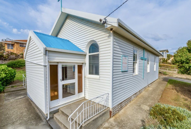
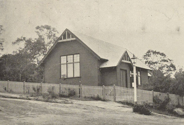
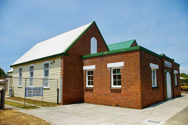
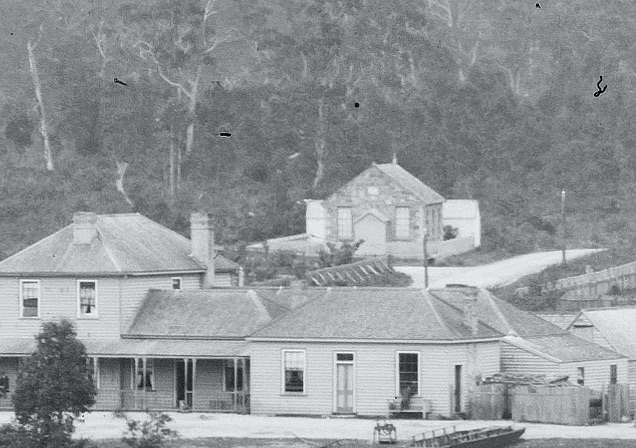
No. 735 - Wivenhoe - Salvation Army Hall

Image
Wivenhoe is a suburb of Burnie situated on the east bank of the Emu River. It has developed into an industrialised area which is located about 3 kilometres south-east of the city centre. It is named after the town (and parish) of Wivenhoe in Essex County, by Captain Henry Butler Stoney in the 1850's. The Salvation Army was formed at Burnie in the 1890’s and further ‘outposts’ were established in neighbouring Wivenhoe in the 1940s and at Montello, Upper Burnie, in the 1950s. There are few available records about the Wivenhoe Salvation Army Hall and I have found only a single photography of the building which can be seen in a general view of the suburb. The first public service at the hall was held on Sunday 17 December 1944. This was reported in the Burnie Advocate: “The first public service held in the new Salvation Army Hall at Wivenhoe was conducted last evening by Major R. Sutton. There was a large gathering. The hall, situated in Smith street, was erected on a block of land don

No. 734 - Penguin - Primitive Methodist Chapel (1866-1872)

Image
Penguin is a seaside town situated approximately 10 kilometres west of Ulverstone. It was established in the 1860’s and was one of the last coastal towns in the northwest to be settled. The Victorian gold rush created a renewed demand for timber and consequently wood cutters and splitters moved into the area. The settlement was named by the botanist Ronald Campbell Gunn after the penguin rookeries that were once common along this part of the coast. This article’s focus is on Penguin’s first Primitive Methodist Chapel which was built in 1866 and taken over by the “Independent Methodists” in 1872. A second Primitive Methodist Church (1874-1903) and the present Uniting Church (1903) will be the subject of future articles. The history of Methodism and Penguin’s Methodist Churches is somewhat complex. It can be summarised as follows: 1866 - A Primitive Methodist Chapel was built on a hill on               the Western end of Main Street (the site of the Uniting               Church). 1868 -

No. 733 - Claremont Methodist Church (1915-1962)

Image
Claremont is a suburb of Greater Hobart. It is named after Claremont House built in the 1830s by Henry Bilton. Bilton purchased the property from John Pascoe Fawkner in 1825 and increased the size of the estate over the next half century. Upon Bilton’s death in 1889, the 700 acre property was subdivided, opening the way for later suburban development. In 1914 Claremont was developed as a temporary Army training camp. At this time the area had only a few scattered houses and a railway station in what was a still a mostly rural setting. The first Methodist church in the Claremont area was a chapel that was established at Roseneath in 1836. This was a simple log chapel that was destroyed around 1850 when a large tree fell across the building. More than half a century was to pass before a second church was established at Claremont. In 1894 Reverend W.R. Cunningham visited Roseneath with the intention of recommencing services. In July 1913, Reverend H.A. Overland and Reverend J.A Penna m

No. 732 - Ridgley Gospel Hall

Image
Ridgley lies approximately 15 kilometres south of the city of Burnie and in recent years the settlement has become a commuter suburb. Ridgley was originally a small farming centre established by the Van Diemen's Land Company. The town has been well served by a number of religious denominations including Anglican, Methodist, Catholic and the Christian Brethren. Although Ridgley’s Brethren Gospel Hall appears to be a modern building, the brick veneer church replaced a much older wooden hall that was built at the turn of the 20th century. Like many Brethren churches, little information is available in newspaper records as the denomination tended to avoid publicity. A report in the Burnie Advocate in 1922 concerning the establishment of a Catholic church in the township mentions that there were already Anglican and Methodist churches as well as a Gospel Hall. An earlier report from 1916 mentions that a Christian Brethren conference was attended by some 300 in the Ridgley pubic hall an

No. 731 - Huonville Community Church

Image
Huonville is a small town on the banks of the Huon River which is situated approximately 35 kilometres south of Hobart. Huonville was not originally intended to be the site of a town as a nearby settlement at Ranelagh (then called Victoria) was planned as the main centre of the district. However Huonville’s location at a bridge crossing the Huon River led to it supplanting Ranelagh as the larger of the two settlements. The Huonville Community Church describes itself as “an independent Bible believing Christian Church affiliated with Churches of Christ in Victoria and Tasmania”. The church which is situated on Huonville Main Road is built in a style resembling that adopted by the Seventh Day Adventist Church in the 1960s and 1970s. However, the building is a former Congregational Church that was built in 1965, replacing an earlier stone church which stood at the intersection of Wilmot Street and Main Road. The new brick building was probably one of the last Congregational churches b

No. 730 - Lebrina - St Patrick's Catholic Church

Image
Lebrina is a small village situated approximately 10 kilometres north of Lilydale in North East Tasmania. The settlement was earlier know as Hall’s Track before the name Lebrina was adopted when railway station on the North-eastern line was built. Lebrina is derived from an aboriginal word meaning "house" or "hut". Lebrina once had three churches: a Methodist church, an Anglican church dedicated to St Andrew and St Patrick’s Catholic Church. Reports of the St Patrick’s church published in the region’s newspapers are sparse and I have yet to find a photograph of the building which has long gone. The church opened December 1931 in a building previously used as a Druid’s Hall. The Ancient Order of Druids, a fraternal society, established a Lodge at Lebrina in 1909 which was named “Dreadnought No. 34”. Fifteen years were to pass before the Druids built a hall in the township. In July 1925 Launceston’s Examiner reported on the opening of Lebrina’s new Druid’s Hall: “T

No. 729 - Montagu Bay - St James' Anglican Church (1966-2019)

Image
Montagu Bay is a suburb of Hobart located on the eastern shore of the Derwent River, about four kilometres from central Hobart. The suburb’s name appears to come from Algernon Montagu, an Attorney General and judge in Van Diemen’s Land. He established a property, Rosny House, in the vicinity of Montagu Bay. Regular Anglican services at Montagu Bay began in the late 1940’s when an old army “musset hut” was acquired as a temporary place of worship. The building was later dedicated to St James. In the 1950’s fundraising for a church became the focus of the community. When an opportunity to purchase the Montagu Bay Congregational Church was presented, this was eagerly taken up. The Anglicans had rented the church since 1964 thus it was a natural progression to purchase the building in 1966. Soon after this the old “musset hut” was moved onto the site. This was attached to the church and used for Sunday school activities. A porch was added to the church in 1972. The church’s closure in 20

No. 728 - Beaconsfield Gospel Hall (1882-1898) - "Too freely ventilated"

Image
The town of Beaconsfield, previously known as Brandy Creek, dates back to the late 1840s when small quantities of gold was discovered in the area. Commercial gold mining only got underway in the 1870s which led to a substantial growth in the town’s population. Brandy Creek was renamed Beaconsfield in 1879 in honour of Benjamin Disraeli, 1st Earl of Beaconsfield and British Prime Minister. By this time the reef was the richest gold discovery anywhere in Australia and virtually overnight Beaconsfield became Tasmania's third largest town. As a mining boom town, Beaconsfield attracted a number of religious denominations with seven churches operating in the township at one stage. Amongst these was a gospel hall which was active from 1882 through to the late 1880s. Very little is known about this building and there are no reports in local newspapers about its construction or opening. The only record of the building’s location is a report in 1883 in Launceston’s Daily Telegraph which n

No. 727 - Lindisfarne - St Aidan's Mission Hall (1907-1926)

Image
Lindisfarne is an eastern shore suburb of Hobart. It was named after "Lindisfarne House", a property situated in the adjoining suburb of Rosny. The area was originally known as Beltana but this was changed to Lindisfarne in 1903. In the early 1890s the first Anglican services at Lindisfarne were held in a “recreation pavilion” and later in the local State school. Fundraising for building a place of worship began in the late 1890s with the aim of establishing a Mission Hall which could also be be used for social gatherings. By 1907 sufficient funds had been raised for the project to proceed. The Mercury reported on the ceremonial laying of the foundation stone that took place on Saturday 17 August 1907: “Lindisfarne has gone ahead so much of late that the residents there who are members of the Anglican Church have long felt the necessity for a building which would at once fulfil the requirements of a church and a hall for business and social meetings. They have been working

No. 726 - Wynyard Gospel Hall (1910 - 2019)

Image
Wynyard is a town on the North West coast approximately 20 kilometres west of the city of Burnie. The area around Wynyard was originally named Table Cape by the explorers Bass and Flinders. The name was changed to Wynyard in the 1850s, in honour of Edward Buckley Wynyard, Lieutenant-General of the New South Wales Corps. In his capacity as commander of troops in New South Wales, Van Diemen’s Land and New Zealand, Wynyard visited Table Cape in 1850-1. Wynyard’s Bible Chapel, previously known as the Wynyard Gospel Hall, opened in early 1910. It replaced an earlier Christian Brethren church established in the 1870’s. The earlier building had previously been a small wooden Anglican church built in the old cemetery grounds (located on Jackson Street) which opened in 1854 or 1855. The building was acquired by the Brethren following the construction of St Stephen’s Anglican church in 1873. The old church was removed to a site at the intersection of Jackson Street and Quiggin Street. The ha

No. 725 - Huonville Congregational Church (1872-1965)

Image
Huonville is a small town on the banks of the Huon River which is situated approximately 35 kilometres south of Hobart. Huonville was not originally intended to be the site of a town as a nearby settlement at Ranelagh (then called Victoria) was planned as the main centre of the district. However Huonville’s location at a bridge crossing the Huon River led to it supplanting Ranelagh as the larger of the two settlements. Huonville’s former Congregational church dates back to the late 1840s when a simple wooden church was built by Thomas and William Walton. In 1838 the Walton’s acquired 640 acres of land which covered much of modern Huonville. In 1845 William Barnett, “an agent of the Congregational Union”, was appointed to minister at the nearby settlement at Franklin. It was shortly after Barnett’s appointment that the Walton’s built a chapel at Huonville. In 1859 a report in the Hobart Courier mentions that a “great improvement has been effected in the Congregational Chapel orig