Posts

Showing posts from January, 2022

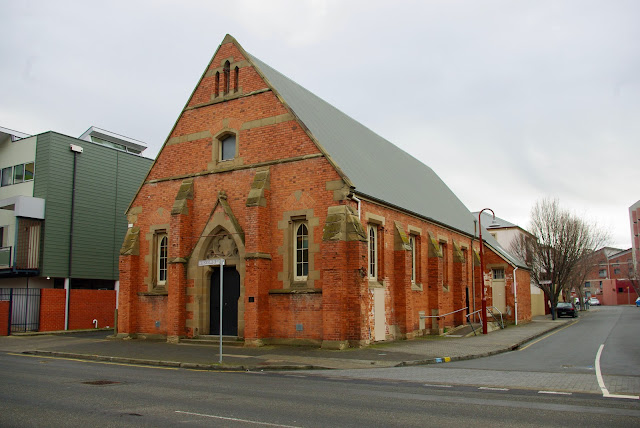
No. 1044 - Hobart - Wesley Hall (1826)

Image
Wesley Hall, which is located on Melville Street, was constructed as a chapel in 1826. This makes the building the second oldest Methodist Church in Australia and the oldest surviving Methodist place of worship. In 1840 the chapel was replaced by a new church built alongside Wesley Hall. A public notice published in the Colonial Times and Tasmanian Advertiser provides a few details concerning the chapel’s opening on Sunday 19th February 1826: “The Melville-street Chapel, being now completed, Public Worship will henceforth be performed in it on Sabbath-Days, at Eleven o'Clock, in the Morning, and at Six in the Evening; and also every Wednesday Evening at Seven o’Clock. On the occasion of its Completion, two Sermons will be preached next Sunday, at the usual Hours of Worship, by the Reverend B. Carvosso; when Collections will be made to assist in defraying the heavy expenses incurred in the erection of this Public Building. As there is a very considerable Debt on it, borne gratuitou

No. 1043 - Dromedary - St Martin's Anglican Church (1922-1967)

Image
Dromedary is mostly a rural area in the Derwent Valley and is located about 15 kilometres west of the town of Brighton. Mount Dromedary, after which the area is named, was was first recorded by Captain John Hayes in 1794 as it resembled a profile of a camel. Dromedary has had only one church and this was destroyed in the devastating bushfires which swept across southern Tasmania in 1967. Apart from a photograph of a stained glass window, no image of the church is available in the public domain. I am hopeful that the publication of this article might result in a photograph coming to light. Fundraising for the construction of an Anglican church began after half an acre of land was donated for this purpose by Mr Hughes of High Sutherland. The foundation stone for a brick church was ceremonially laid on Saturday 11 March 1922. The event was recorded by the local correspondent for the Hobart Mercury: “Saturday was a big day in the history of peaceful Dromedary, when the foundation-stone

No. 1042 - Waratah - The Salvation Army Hall (1890)

Image
Waratah is a former mining town located approximately 80 kilometres south of Burnie. For a brief time Waratah was the site of the largest tin mine in the world. The town had its beginnings in 1871 when James "Philosopher" Smith discovered tin at Mount Bischoff. The population of Waratah reached 2500 at its peak but is now under 300. Information about the establishment of Waratah’s Salvation Army hall has been an unexpected challenge. Margery Godfrey’s “Waratah - Pioneer of the West” has a detailed chapter on the town’s churches but offers no clues as to when the hall or “barracks” was built. A thorough review of newspaper articles from the late 19th century provide a wealth of information about the Salvation Army’s activities but very little about the establishment of its hall or ‘barracks’. A single report from the Launceston Examiner’s Waratah correspondent in March 1890 states that: “Salvation Army progressing, the new barracks near completion”. It is safe to assume that t

No. 1041 - South Bridgewater (Granton) - St Peter's Chapel (1846)

Image
Granton is a suburb of Greater Hobart and is situated approximately 20 kilometres north of the city centre. Originally known as South Bridgewater, it was renamed as a tribute to Charles Henry Grant, one time General Manager of the Main Line Railway which opened in 1876. There is very little information available about St Peter’s chapel. The site of chapel and its cemetery are barely noticeable off Granton Main Road. In ‘Our Heritage of Anglican churches in Tasmania’, Dorothea Henslowe records that a chapel was licensed at Bridgwater South in December 1846. Another source of information about the building is found in Irene Schaffer’s article “The Story of the forgotten St. Peter’s Church of South Bridgwater”. Schaffer writes that the chapel was situated on a portion of 30 acres of land granted to former convict, William Mansfield, at the Black Snake Run: “William Mansfield gave a portion (2 roods) of his land for the purpose of erecting a Chapel, to the Church of England…..Further pro

No. 1040 - Hobart - Mission to Seafarers - Hobart Station

Image
The Mission to Seafarers (originally called The Mission to Seamen) is a Christian welfare charity serving merchant crews around the world. It operates through a global network of chaplains, staff and volunteers. The missions provide practical, emotional and spiritual support through ship visits, seafarers centres and welfare and emergency support services. The Mission to Seafarers has its roots in the work of an Anglican priest, John Ashley, who in 1835 was asked how people working on ships in the Bristol Channel attended church. Recognising the needs of seafarers living on the four hundred sailing vessels in the Channel, Ashley created the Bristol Channel Mission. In 1839 he redesigned a ship, a cutter named Eirene, for mission work. The ship’s main cabin was converted into a chapel accomodating 100 people. John Ashley’s work inspired similar ministries across Britain and in 1856 these groups were formally organised under the name ‘The Mission to Seamen Afloat, at Home and Abroad’. I

No. 1039 - Marrawah Baptist Church

Image
Marrawah is a small West Coast town located approximated 50 kilometres south west of Smithton. Marrawah is Tasmania's westernmost settlement and the furthest town from Hobart. It was once a rich timber district with a railway line which fed the sawmills at Smithton. Marrawah is an aboriginal word for "gum tree". The first Baptist meeting at Marrawah took place in 1952 with a church constituted in 1954. Early meetings were held in the Marrawah community hall and a church was built in 1957. The church was built by Ron Clarke of Smithton with the help of volunteer labour. The church closed in 2023 with the congregation combining with the Smithton Baptist church. The final service too place on Sunday 5 February.  * Additional information about this church welcomed as all articles are updated. I can be contacted through this page or my Facebook page "Churches of Tasmania" which is linked < HERE > . Marrawah Baptist church - Image source: Google Street-view 2010

No. 1038 - Hobart - St David's Mission Chapel (1885-1914)

Image
The former Mission Chapel is located on lower Campbell Street in a dockside area previously known as Wapping. The Mission was an extension of St David’s Cathedral, as an outreach to the “poorer classes” living in a deprived and disreputable part of the city. The Mission’s foundation stone was ceremonially laid by the Bishop of Tasmania on Monday 24 November 1884. A lengthy report of the ceremony was published in the Hobart Mercury. This provides details about the Mission’s origins and of the building’s function and appearance: “It is now over two years since a movement was set on foot to establish a mission chapel in connection with St. David's Cathedral, with the object of more effectively reaching the poorer classes of the city. The late incumbent, the Very Rev. Dean Bromby, entered with his usual zeal and heartiness into the project, and chiefly through his instrumentality a fund was opened, towards which collections have been made monthly in the cathedral and parish of St. Da

No. 1037 - Kempton - St Mark's Anglican Church (1830-1845)

Image
Kempton is a small town on the Midlands Highway, about 45 kilometres north of Hobart. It was first settled by Anthony Fenn Kemp in 1817. He was given a grant of land, now the Mount Vernon estate. The town was first named Green Ponds after some small green water holes found near the town. The first Anglican church at ‘Green Ponds’ was a small timber church dedicated to St Mark. In the Hobart Town Almanac of 1829 there is a reference to a “neat little church [at Green Ponds] in the process of erection, and now nearly finished, built chiefly at the expense of the inhabitants”. The church was dedicated to St Mark’s and consecrated by Archdeacon Broughton in April 1830 with Lieutenant-Governor George Arthur in attendance. The Hobart Town Courier reported: “We have the pleasure to announce to the inhabitants of the Green Ponds and its neighbourhood, that the Venerable Archdeacon has fixed on Thursday next the 8th instant, as the day on which he will consecrate the Chapel at the Green Ponds,

No. 1036 - New Norfolk - Derwent Valley Salvation Army Corps

Image
New Norfolk is a large town on the banks of the Derwent River approximately 40 kilometres west of Hobart. It is a historic town mostly settled by Norfolk Islanders soon after its establishment. When Governor Lachlan Macquarie visited the township he named it Elizabeth Town after his wife. However, it was later decided to adopt the name New Norfolk to acknowledge the new settlers. New Norfolk has been the home of at least 10 religious denominations since the area was settled over two hundred years ago. The Salvation Army had an early presence in the town with a group of evangelists from Hobart preaching in 1887. There are few records of the ‘Army’s’ early years in the New Norfolk. Gatherings took place in a building on Montague Street. After the Great War the expense involved in maintaining a Corps at New Norfolk led to the withdrawal of the Salvation Army’ in about 1920. The ‘Army’ was reestablished in the town in 1936 with meetings held in the old library hall. When a bequest of £500

No. 1035 - Lower Mount Hicks Methodist Church (1890-1972)

Image
Lower Mount Hicks is a rural settlement situated approximately 10 kilometres south of Wynyard. Two churches were built in the greater Mount Hicks district; a Methodist church that opened in the 1890s and a Gospel Chapel which was established in the 1950s. Both churches have closed. Methodists services began at Mount Hicks in the 1880s which led to the construction of a church on what is now the Old Mount Hicks Road in the vicinity of the cemetery. I have not yet located a photograph of the building. The opening of the church took place on Sunday 14 December 1890. The occasion was reported by the Launceston Examiner and also the Wellington Times and Agricultural and Mining Gazette: “The new Methodist Free Church was opened on Sunday morning last by the Rev. W. H. Bowe, who conducted the service; the Rev. T. Ellis preaching in the afternoon; both services being well attended. The church is a weatherboard building, 18ft by 25ft, and has been erected on ground kindly given by Mr W. Hyland

No. 1034 - Longley - St Luke's Anglican Church (1893-1897) 'Baptism by Fire'

Image
Longley is a rural settlement approximately 20 kilometres south of Hobart. The area was originally named Leslie, a name that has been preserved by Leslie Hill, on the eastern side of Longley. Three Anglican churches were built at Longley, all of which were destroyed by bushfires. The first church was built in 1892 and consecrated and dedicated to St. Luke in February of the following year. This building was lost in the ‘great bushfires’ that swept across southern Tasmania in the summer of 1897/8. A second church was built and rededicated in 1898. This building was similarly destroyed in a bushfire in 1931. The third church, built in 1932, was lost in the 1967 bushfires. This building was not replaced. The focus of this article is on Longley’s first Anglican church which only stood for a little over four years. The church was a small weatherboard structure build by ‘Mr Stuart’. The church’s foundation stone was ceremonially laid by Bishop Montgomery on Tuesday 15 March 1892. The Mer

No. 1033 - Rosebery - St George's Anglican Church (1930-2001)

Image
Rosebery is a mining town located on the Murchison Highway approximately 60 kilometres north of Queenstown. The town’s name is taken from a mine pegged out by Tom McDonald in 1893. He named it the Rosebery Gold Mining Company after the Prime Minister of England, Lord Rosebery. The develop of the town only took off in the 1920s. In February 1930 a visitor to Rosebery remarked on the development that had recently taken place: “Since our last visit over three years ago, Rosebery has made immense strides, and a now town has practically arisen. Building operations are still going on to provide new houses and places of worship. Ringed around by mountains of imposing height - Mounts Murchison, Read and Black, and by lower heights, clothed by trees and bush, Rosebery is really beautifully situated, and might be considered a most delectable residential town, if it were not for the heavy rainfall, the roads, alternately dusty and muddy, and the comparatively few days of sunshine and warmth”. “A