Posts

Showing posts with the label Southern Tasmania

No. 1078 - Braeside Road Methodist Church (1905-1968)
Image
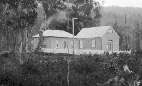
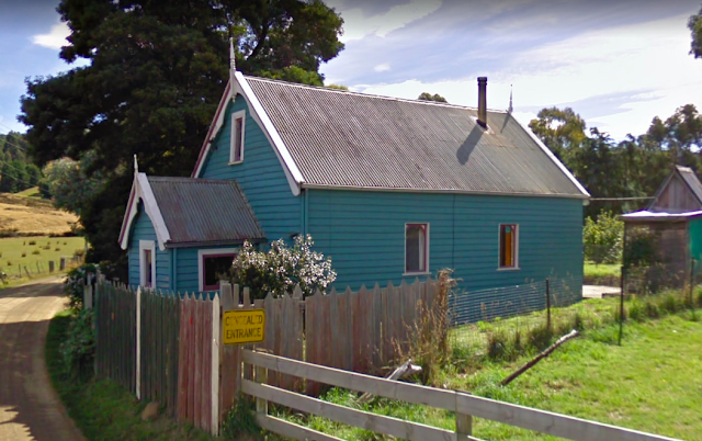
Braeside is a rural settlement in the Huon Valley, approximately 2 kilometres south of Franklin, centred along Braeside Road. Orcharding and saw-milling were the main industries in the area around the turn of the 20th century when the settlement had a school and church. Very little information is available about the former Braeside Road Methodist church. The following is recorded in Max Stansall’s ‘Tasmanian Methodism’: “During 1863 proposals to hold services in the area then known as Chitty’s Road were put forward. However it was not until 21/1/1897 that the first Trust meeting was held. The church-building was completed between 1900 and 1903 and a Sunday-school was operating some two years later. Evidently the Cause did not flourish for, on 1/4/1968, the Quarterly Meeting authorised the church’s closure”. A search of newspaper records provides a few further details about the church. In 1900 a report on the annual sessions of the Hobart Wesleyan District Synod records that permission...

No. 1034 - Longley - St Luke's Anglican Church (1893-1897) 'Baptism by Fire'

Image
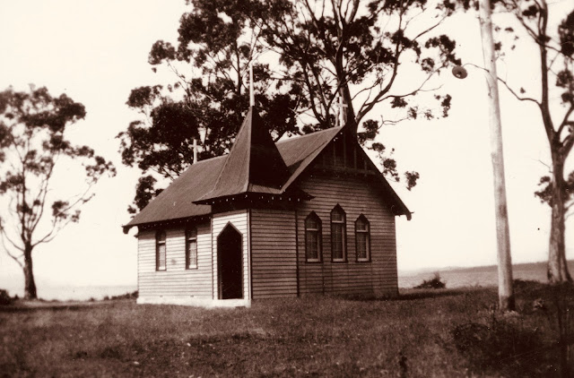
Longley is a rural settlement approximately 20 kilometres south of Hobart. The area was originally named Leslie, a name that has been preserved by Leslie Hill, on the eastern side of Longley. Three Anglican churches were built at Longley, all of which were destroyed by bushfires. The first church was built in 1892 and consecrated and dedicated to St. Luke in February of the following year. This building was lost in the ‘great bushfires’ that swept across southern Tasmania in the summer of 1897/8. A second church was built and rededicated in 1898. This building was similarly destroyed in a bushfire in 1931. The third church, built in 1932, was lost in the 1967 bushfires. This building was not replaced. The focus of this article is on Longley’s first Anglican church which only stood for a little over four years. The church was a small weatherboard structure build by ‘Mr Stuart’. The church’s foundation stone was ceremonially laid by Bishop Montgomery on Tuesday 15 March 1892. The Mer...

No. 1025 - Gordon - Union Church (1933-1967)

Image
Gordon is a settlement on the Channel Highway about 25 kilometres southwest of Cygnet and which fronts onto the D’Entrecasteaux Channel. Gordon was once an orchard growing district. The area was previously known as 'Herne Bay' and 'Three Hut Point’. The Gordon Union Church, which opened in February 1933, replaced an early church also shared by the Methodist and Anglican communities. In 1932, when the construction of a new church began, the local correspondent for Hobart’s Mercury recalled : “Over 90 years ago a small dwelling was erected on the site where the new church is being built by two of Gordon’s earliest settlers, Messrs. John Behrens and Frederick Webber, for a Mr. John Abbott, an Englishman, who lived in a fine home with beautiful gardens and grounds, known as Rookwood, in the vicinity where Mr. Mason's general store now stands in Gordon. Many years later, after the disastrous bush fires of 1897 swept the State, the Gordon School, which for many years also ser...

No. 1010 - New Norfolk - High Street Catholic Chapel (1850 - 1887)

Image
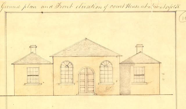
New Norfolk is a historic town on the banks of the Derwent River, approximately 40 kilometres west of Hobart. It grew dramatically when settlers from Norfolk Island moved into the district after 1807. When Governor Lachlan Macquarie visited the township he named it Elizabeth Town after his wife. However, it was later decided to adopt the name New Norfolk, acknowledging the district’s many Norfolk Islanders. The first Catholic Mass to be held in the township was held by Father Philip Connolly in 1821. In about 1850, New Norfolk’s police court house, located on High Street, was purchased by the Catholic Church for the sum of £450. The building was converted for use as a presbytery and the courtroom itself became the chapel. The earliest reference to the building’s use as Catholic chapel dates to January 1850 when the Colonial Times reported that the chapel was the venue for a subscription ball: “On Friday evening….the delightful town of New Norfolk was enlivened by the merry pipe and ta...

No. 987 - Mangalore - St Martin's Anglican Church (1914-1967)

Image
Mangalore is a semi-rural district on the Midland Highway approximately 6 kilometres north of Pontville. It was once a farming area but in recent years it has undergone some suburban development. The area is named after Mangalore Tier, a feature that was first marked on maps in the early 1820s. Very little information is available about St Martin’s and I have yet to find a photograph or a description of the building. Most information about the church’s established comes from a single report published in the Hobart Mercury in November 1913: “During the last four of five years the population of this district has increased so rapidly that the Rev. J. Corvan recently opened a Church of England Sunday-school at the railway station until a suitable building was erected. Mrs Graf gave a block of land (very conveniently situated) to the church trustees, and an energetic committee has been at work endeavouring to raise the necessary funds. A concert, a lecture, contributions in the shape of c...

No. 983 - Hollow Tree - Montacute - St James' Chapel

Image
Montacute is an historic property in the Clyde Valley situated 14 kilometres south of Bothwell, on the Hollow Tree Road. This road was once the coach link between Hamilton and Bothwell. Montacute was was purchased by Captain William Langdon and added to his original land grant of 1823. In 1857 Langdon built a family chapel at Montacute. William Langdon was born in 1790 at Montacute vicarage, Somerset, England; the fifth son of Rev. William Langdon. He joined the Royal Navy at the age of 13 at the time of the Napoleonic wars. Following the Peace of Paris, Langdon retired from the navy and bought a merchant vessel, The Lusitania, and sailed to Sydney and Hobart Town, where he landed in 1821. Over the next few years Langdon acquired several more merchant ships. In 1823 Langdon received a grant of 1500 acres on the Clyde River to which he added another property which he named Montacute. In September 1834 Langdon settled in Van Diemen's Land with his wife and a daughter. Langdon is res...

No. 980 - Glenfern - St Mary Magdalene - Anglican Church (1908-1954)

Image
Glenfern is a rural community about 10 kilometres southwest of New Norfolk. The district was previously known as Dry Creek until the 1880s when a State school and post office were established at the settlement. St Mary’s Anglican church is the only place of worship built at Glenfern. One of the earliest descriptions of the settlement was published in the Hobart Mercury in 1903: “The district known as Glen Fern is situated on the creek of the same name, and extends up the stream for a distance of four or five miles from the State School, which is six miles from New Norfolk, in a westerly direction. The creek is supported on both sides with high ranges, but rich valleys, varying in width, prevail, on which fully two dozen settlers are enabled to make comfortable livings. Most of them combine the two industries of fruit and hop growing, but none of the areas are very large. The only public building is the State School, wherein divine service is conducted occasionally by a Church of Englan...

No. 979 - Crabtree - Salvation Army Hall (1917-1967)

Image
Crabtree is a rural settlement in the local government area of Huon Valley and is located about 15 kilometres north of Huonville. It was once an important timber and orchard-growing district. The settlement is named after the Crabtree Rivulet. Crabtree has had only two places of worship; a Salvation Army hall which was built in 1917 and an Anglican church hall which opened in 1929. The State school was used for religious services by both the Salvation Army and the Anglican’s prior to the construction of the two halls. The activities of the Salvation Army at Crabtree were an extension of the the Corp’s that was established at nearby Ranelagh in the late 1890s. In both settlements, orchard workers were an important source of Salvation Army supporters. The Crabtree hall opened on Saturday 2 June 1917 being built for holding religious services as well as a Sunday school. The hall’s opening was recorded by the Huon Times: “The new Salvation Army Hall was opened on Saturday afternoon… by M...

No. 969 - Adamsfield - Ministering on the "Ossyfield"

Image
Adamsfield was an isolated mining settlement situated in the rugged southwest, approximately 10 kilometres west of the Florentine Road and about 5 kilometres from Lake Gordon. Now a ghost town, it was established when rich deposits of osmiridium were found at Adams River Field in the 1920s. At this time osmiridium had a value of about £30 per ounce; several times the value of gold. A mining rush began in 1925 and a camp of about 1,000 people emerged. By the late 1930s the rush was over and by the 1960s commercial mining activity had ceased altogether. At its peak Adamsfield’s population was sizeable and the township had a community hall, post office, a field hospital, a school and a handful of shops. Although no churches were established, religious services were held in the community hall. Most of Tasmania’s early mining settlements invariably had at least one church established but Adamsfield’s remote location and the short duration of its population peak, mitigated against a permanen...

No. 949 - Kaoota - Seventh Day Adventist Church

Image
Kaoota is a rural settlement approximately 18 kilometres south-west of Kingston. Kaoota once had a coal mine with a dedicated railway. Mining petered out when the quality of coal started to decline. Kaoota is an aboriginal word for dusk. Kaoota’s former Seventh Day Adventist church is the only church that was established at the settlement. It was built in 1934 after Mr J.C. Warren, an elder of the church, moved into the area. It was the sixth ‘Adventist’ church to open in Tasmania. The original church, which measured only 36ft. by 18ft., was built from the timber of a single giant tree. The church was dedicated on Sunday 4 March 1934. The date of the church’s closure is not known but it is believed to be in the early 1960s, prior to the opening of a Seventh Day Adventist Church at Margate. The church has been converted into a house and is located at the junction of Pelverata Road and Coal Mine Road. Additional information about this church is welcomed as all articles are continua...

No. 936 - Pawleena - The Church of the Holy Cross (1910 - 2002)

Image
Pawleena is a small rural community approximately 6 kilometres north of Sorell. The settlement was originally known as ‘Cherry Tree Opening’ and the name Pawleena appears to have been adopted after 1923. Pawleena is an Aboriginal word, used by southern tribes, meaning 'gun' or musket. Aside from a handful of reports in local newspapers, there is little information about the Anglican Church of the Holy Cross. The church was built in 1910 and dedicated by Bishop Mercer on Wednesday 14 September. A correspondent for the Mercury reported: “In perfect weather on Wednesday, the Bishop of Tasmania dedicated the new Church of S. Cross [sic] at Cherry Tree Opening. The church stands about four miles from Sorell on one of the prettiest roads in the district. A large number of people journeyed from Sorell and the district (reaching to Nugent to Dunalley) to take part in the interesting and important ceremony. The building, which was erected by Mr, Arthur Quinn, is of a size to hold a hun...