Posts

Showing posts with the label Anglican

No. 1069 - Northdown - St Thomas' Anglican Church (1845-1878)

Image
Northdown is a fertile agricultural district approximately 15 kilometres east of Devonport. In 1826 the area was settled by Captain Bartholomew Thomas who established the Northdown estate. Captain Thomas met a violent death in 1831 when he and his overseer, Mr Parker, were speared to death by a group of men from the ‘Big River tribe’. In 1845, St Thomas’, the first Anglican church in the district, was built about three kilometres from the present church on a site close to the sea. Only the old church’s cemetery remains. St Thomas was one of the first churches to open on the North West coast at a time when Northdown was the only settled area between Stanley and the Asbestos ranges. The parish covered a vast area between the Rubicon and Blythe rivers. Bishop Francis Nixon opened and consecrated the church on Wednesday 30 April 1845. The Bishop’s visit to Northdown was not without incident. The Hobart Courier reported: “On Wednesday the new church at Port Sorell was opened for Divine Ser...

No. 1034 - Longley - St Luke's Anglican Church (1893-1897) 'Baptism by Fire'

Image
Longley is a rural settlement approximately 20 kilometres south of Hobart. The area was originally named Leslie, a name that has been preserved by Leslie Hill, on the eastern side of Longley. Three Anglican churches were built at Longley, all of which were destroyed by bushfires. The first church was built in 1892 and consecrated and dedicated to St. Luke in February of the following year. This building was lost in the ‘great bushfires’ that swept across southern Tasmania in the summer of 1897/8. A second church was built and rededicated in 1898. This building was similarly destroyed in a bushfire in 1931. The third church, built in 1932, was lost in the 1967 bushfires. This building was not replaced. The focus of this article is on Longley’s first Anglican church which only stood for a little over four years. The church was a small weatherboard structure build by ‘Mr Stuart’. The church’s foundation stone was ceremonially laid by Bishop Montgomery on Tuesday 15 March 1892. The Mer...

No. 1033 - Rosebery - St George's Anglican Church (1930-2001)

Image
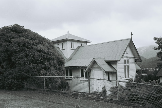
Rosebery is a mining town located on the Murchison Highway approximately 60 kilometres north of Queenstown. The town’s name is taken from a mine pegged out by Tom McDonald in 1893. He named it the Rosebery Gold Mining Company after the Prime Minister of England, Lord Rosebery. The develop of the town only took off in the 1920s. In February 1930 a visitor to Rosebery remarked on the development that had recently taken place: “Since our last visit over three years ago, Rosebery has made immense strides, and a now town has practically arisen. Building operations are still going on to provide new houses and places of worship. Ringed around by mountains of imposing height - Mounts Murchison, Read and Black, and by lower heights, clothed by trees and bush, Rosebery is really beautifully situated, and might be considered a most delectable residential town, if it were not for the heavy rainfall, the roads, alternately dusty and muddy, and the comparatively few days of sunshine and warmth”. “A ...

No. 1018 - Hadspen - St Stephen's Anglican Church (1845-1961)

Image
Hadspen is a dormitory town on the South Esk River approximately 10 kilometres south west of Launceston. The early settlement was centred on a village near Reibey’s Ford. It is believed that George Frankland (Surveyor-General 1827 to 1838) named the settlement Hadspen after an estate in his native county, Somerset. Thomas Reibey’s iconic Church of the Good Shepherd, which remained uncompleted for almost a century, is the church most closely associated with Hadspen. Few will know that another Anglican church, St Stephen’s, served the community for almost 120 years before it was removed with the eventual completion of Reibey’s church in 1961. Little is known about this church and I have found only one photograph which captures a partial section of this building. I am hopeful that an image may exist. The church was moved after it was sold to the Methodists but I have yet to establish where it was moved or even if it still exists. The foundation stone for St Stephen’s was laid by Bishop N...

No. 1015 - Blackmans Bay - St Peter's Anglican Church (1968-2016)

Image
Blackmans Bay is located adjacent to the town of Kingston and is approximately fourteen kilometres south of Hobart. It is named after James Blackman who made a claim for a grant of land in the area in about 1844. It was once a popular place for holiday shacks but is now a residential area. Plans to build a church at Blackmans Bay were developed in 1960. In 1968 the foundation stone for the building was laid and the church was constructed at a cost of $12 000. The church was dedicated to St Peter in October 1968. St Peter’s closed in 1916 and sold in the following year. The church and attached land has recently been developed for housing units. St Peter's Anglican Church (Google street view) St Peter's at Blackmans Bay (undated) photo supplied Source: Stephens, Geoffrey, The Anglican Church in Tasmania: a diocesan history to mark the sesquicentenary, 1992, Trustees of the Diocese, Hobart, 1991.

No. 1013 - Glenorchy - St Andrew's Anglican Church (1958-1975)

Image
The city of Glenorchy is located approximately 7 kilometres north of Hobart's CBD. Glenorchy means ‘glen of tumbling waters’ and it is believed that Governor Lachlan Macquarie named the area after his wife’s birthplace; Glen Orchy, Argyllshire. St Andrew’s was built in 1958 and was opened and consecrated in the same year. The building was an old army hut from the Brighton Military Camp which was transported to Glenorchy and reassembled with some modification. As can be seen in the photograph, the church is constructed of rough hewn vertical board with a corrugated iron roof. The sanctuary and altar were built by Richard Lord. St Andrew’s was a short-lived church with religious services ceasing in the early 1970s. The site was sold and the building removed in 1975. St Andrew's at Glenorchy (1958) Source: Henslowe, Dorothea I. and Hurburgh, Isa.  Our heritage of Anglican churches in Tasmania / by Dorothea I. Henslowe ; sketches by Isa Hurburgh  [S.l  1978

No. 1008 - West Hobart - St John the Baptist (1856-1998)

Image
West Hobart is an inner-city suburb of Hobart immediately west of the city centre. The suburb occupies the high ground below Knocklofty Hill. The West Hobart parish was former in 1844 being carved from sections of St David’s and Holy Trinity parishes. The parish’s first church was built in 1845 [ see No. 992 ] and this building became a Sunday school following the opening of St John the Baptist in 1856. The ‘new’ church was built at a cost of £4300 and was designed by Frederick Thomas who modified the original plans drafted by George Edmund Street. Construction began in December 1852 and building was completed in three years. The church was consecrated by Bishop Francis Nixon in May 1856. In 1902 problems with the foundations which supported the chancel resulted in this section of the building being demolished and rebuilt. The rebuilt section was designed with additional height and included an organ chamber and a vestry. The church is built in the Gothic-Revival style. A window in t...

No. 1007 - Roger River - St Michael and All Angels' Anglican Church (1967-2005)

Image
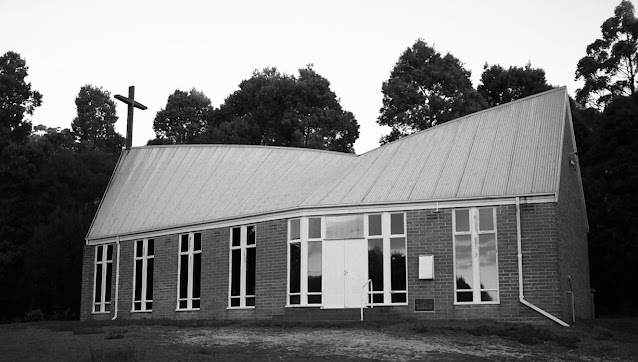
Roger River is located about 25 kilometres south-west of the town of Smithton. Roger River originated as the name of a river front property. A small settlement developed around the Mackay's Sawmill. Consideration was given to calling the settlement Rogerton and the local school was known as the Rogerton school from about 1923. Plans for a church at Roger River were developed in 1964 and in November 1967 the church was opened and dedicated. The modern hexagon shaped brick building has an unusual irregular roofline. Locally it was known as “the church with the broken back”. The church was built with the support of the surrounding communities of Edith Creek, Nabageena, Roger River and Trowutta. St Michael and All Angels’ was consecrated by Bishop R.E. Davies on 2 May 1976. The church closed early this century and was sold in 2005. The building was subsequently converted into a house. St Michaels and All Angels at Roger River (undated) Photographer not known. The former church in 201...

No. 1005 - North Hobart - St Margaret's (1896-2007)

Image
The suburb of North Hobart, as the same suggests, is on the northern fringe of the city centre. It has evolved into a mixed residential and commercial area since it was developed in the 1830s. St Margaret’s Mission on Federal Street (previously Colville Street) was established in 1885 as a 'mission room' located in neighbouring Ware street. In 1896 the Ware Street Mission was replaced by the ‘Holy Trinity Mission Room’ built on Federal Street.  The 'Mission' was became known as St Margaret’s Mission Hall after it was dedicated by Bishop Hay in 1926. The Mercury records the laying of the Mission’s foundation stone in January 1896: “On Saturday afternoon the foundation or memorial stone of a new mission-room, in connection with Holy Trinity Church, was laid in Colville-street North by Mr. Alfred Crisp, M.H.A. for the district, in the presence of a goodly number of people. The new building is to be 60ft. by 25ft., and is being erected in substitution for the temporary room...

No. 1001 - Stanley - St Paul's Anglican Church (1888-2021)

Image
Stanley is a historic town on the northwest coast approximately 80 kilometres west of Burnie. The Van Diemen's Land Company once had its headquarters at Stanley when it was known as Circular Head. The settlement was later named after Lord Stanley, the Secretary of State for the Colonies, who went on to serve three terms as British Prime Minister. This year, on Sunday 31 October, the final service of St Paul's Anglican Church will take place, 174 years after the the opening of Stanley’s first Anglican church in 1847. [ see No. 991 ] The original stone church stood for less than 40 years and was demolished due to significant structural problems. A report in 1882 reveals that these flaws had become urgent: “Mr.Conway condemned the building entirely, considering the foundations [are] the most defective part of the structure. One of the walls is considerably out of the perpendicular, and he thinks the roof, if allowed to remain, will certainly some day collapse altogether from the ...

No. 999 - Tullah - St Andrew's Anglican Church (1912-1982) - "Not cost one penny"

Image
Tullah is a small town on the Murchison Highway approximately 110 kilometres south of Burnie. It was established in 1900 as a remote mining settlement called Mount Farrell. In the 1970s Tullah was used by the Hydro Electric Commission to house workers engaged in the various parts of the Pieman River Power Scheme. At this time Tullah’s population peaked at 2500. The town is divided into two sections; the older northern mining settlement and the newer southern part developed by the Commission. Four churches were built at Tullah representing the Methodist, Catholic and Anglican denominations. These have all closed and in recent years were replaced by the Tullah Community Church. St Andrew’s Anglican church opened in December 1912 but was only consecrated in the following year. A report in the Mercury records the first service taking place on Sunday 15 December: “The first Sunday service has been held in the new Church of England. The building, which is 37ft. long, is not quite completed...