Posts

Showing posts with the label 1940-1947

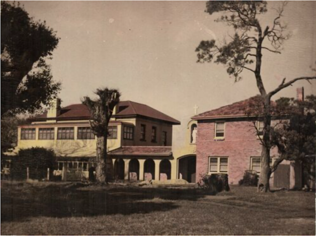
No. 937 - Longford Hall - Carmelite Monastery and Chapel (1948-1973)
Image
Longford is an historical country town approximately 25 kilometres south of Launceston. The district around Longford was first known as the Norfolk Plains after the Norfolk Islanders who were resettled here in 1813. The settlement was originally called Latour and in 1833 it was renamed Longford. In 1948 the Catholic Order of Carmelites established a covent at Longford Hall, a property situated approximately 1½ kilometres from the centre of the town. The property was originally established as the Longford Hall Academy in 1827 by William Gore Elliston. In 1837 Elliston sold the property after he purchased the Hobart Town Courier, a lucrative business which also enjoyed government printing contracts. A later owner of the property, Robert Quayle Kermode, demolished the original schoolhouse and built the existing house. Longford Hall was also the residence of several members of the Archer family. In 1934 it was purchased by Austin and Stella Cooper. The house and its accompanying 100 acr...

No. 848 - Williamsford Catholic Church

Image
Williamsford is a former West Coast mining town on the banks of the Ring River approximately 6 kilometres south of Rosebery. Williamsford was established to house workers of the Hercules Mine run by the Electronic Zinc Company. The town was named after the first manager of the Hercules Mine, Luke Williams. In 1894, a prospector, Joseph Will, found a rich seam of silver at Mount Read. This deposit resulted in the establishment of the Hercules Mine, which reached full production by 1900. Williamsford was connected to Zeehan and its smelter by the 29-kilometre North East Dundas Tramway in 1898. The closure of the Zeehan smelter in 1913 contributed to the closure of the Hercules Mine and the abandonment of Williamsford. When the Electrolytic Zinc Company reopened the Hercules Mine in 1920, primarily for zinc extraction, Williamsford was revived and was repopulated until the mine closed in 1986. Mount Read and the Hercules Mine is also remembered for the haulage line which connected Will...

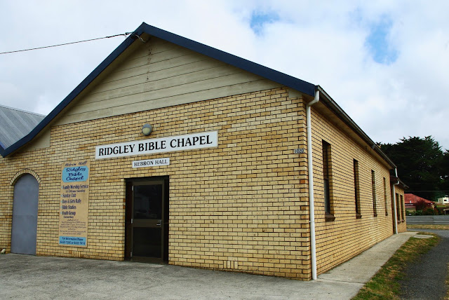
No. 695 - Ridgley - The Bible Chapel

Image
Ridgley lies approximately 15 kilometres south of the city of Burnie and in recent years the settlement has become a commuter suburb. Ridgley was originally a small farming centre established in the 1880’s by the Van Diemen's Land Company. The town has been well served by a number of religious denominations including Anglican, Methodist, Catholic and Christian Brethren. The Ridgley Bible Chapel, previously known as the Hebron Hall, was established in 1941 by a group of ‘evangelical Christians’. In September of that year the Advocate reported: “For the past month or so residents of Ridgley have been interested in the erection of a new hall by a company of Christians which formerly met in the Public Hall. The building is now ready for use, and special meetings to celebrate the opening will be held over this weekend…. A large number of visitors are expected from all parts of the island, and the public is invited to attend these and subsequent services” . While the opening services he...

No. 686- West Pine - The Church of the Ascension

Image
West Pine is a small rural community approximately 8 kilometres south west of Penguin on the North West Coast.  Located west of Pine Road, the area was originally called "Pine Road West”. It was locally known as "West Pine” which was eventually adopted as the official name of the district. The history of the Anglican church at West Pine is complex but can be divided into three distinct periods: 1. 1895 -1924. The first church-school was built in 1895 and was destroyed in a fire in 1924.  2. 1925 -1944. The church-school was replaced by a parish hall. 3. 1944 - 2008. The parish hall was replaced by materials from a church previously located at South Riana. This was effectly a new building and was consecrated as the Church of the Ascension in 1945. A previous article on Churches of Tasmania [ No. 659 ] traced the history of West Pine’s first church-school and the parish hall which replaced it.  This article will focus exclusively on the Church of the A...

No. 572 - Gunns Plains - St Mark's Anglican Church

Image
Gunns Plains is a farming district approximately 25 kilometres south of Ulverstone. It is noted for its impressive limestone caves which are a tourist attraction. The district is named after Ronald Gunn, a botanist and explorer, who discovered the caves in the late 1850’s. Gunns Plains is one of very few districts in the North West where only the Anglican’s established churches. The Anglican’s built not one but three churches. A previous article on Churches of Tasmania told the story of the first two churches which were built in 1900 and 1908. [ No. 560 ] Both of these buildings also accommodated local State schools.   After the closure of the church built at the northern end of Gunns Plains services continued to be held in the ‘church-school’ located at the southern end of ‘Plains’ until the late 1920’s. Following the sale of this building in the 1930’s the proceeds were used to acquire land in central Gunns Plains. In 1939 a small weatherboard church was built by Mr L Bott of...

No. 565 - Beulah - St Matthew's Anglican Church - "A Family House"

Image
Beulah is a small settlement in the foothills of Mount Roland approximately 15 kilometres southeast of Sheffield. The name Beulah is taken from the Bible and means ‘my heaven and my home forever more’. Beulah has had two Anglican churches, the first was built in 1904 and the second was a former Baptist church purchased in 1944. Both churches were dedicated to St Matthew. The establishment of Beulah’s first Anglican church was over ten years in the making. In June 1891 the Examiner reported that when the Bishop of Tasmania was touring the Sheffield district he visited Beulah where “he was met by a large number of residents, the male members of whom were soon hard at work clearing a a bit of primeval forest for a church at some future date”. That “future date” had to wait until 1904. In the interim the small Anglican community had made use of Beulah’s public hall for Sunday worship. In September 1904 the Launceston Examiner reported on the opening and dedication of Beulah’s new An...

No. 449 - The Breadalbane Methodist Church

Image
Breadalbane is a small settlement situated on the Midlands Highway about 10 kilometres from Launceston. The area was previously known as ‘Brumby's Plain’ before it was renamed Breadalbane by Governor Macquarie, after the Earl of Breadalbane, his wife's cousin. Methodist services were held in the convict built Breadalbane Union Church before it burnt down in March 1948. The Methodists then built a small weatherboard church using voluntary labour. It was officially opened on Saturday 25 September 1948 and became a part of the South Launceston Circuit. The church was considered to be the smallest in Tasmania. At the time of the formation of the Uniting Church in 1977 the Breadalbane church was still operating with a membership of three. The date of the church’s closure is not known. The only photograph of the church which I have found is a very small image published in Henslowe’s ‘Tasmanian Methodism’ which has been enlarged and reproduced below. Breadalbane Methodist Church ...

No. 428 - St Andrew's at Bothwell

Image
Bothwell is one of the oldest settlements in Tasmania. It is situated on the Clyde River, about 75km miles from Hobart. The name Bothwell was given by Governor Arthur after "Bothwell" in Scotland. Bothwell is classified as an historic town. The majority of the first settlers were from Scotland. Bothwell once had four churches of which the Anglican, Uniting (Presbyterian) and Catholic remain. Bothwell’s first Catholic church opened in 1864 [ see No. 424 ] but was replaced by a new church that was built in 1940. In the 1930’s fundraising began to build a new church, ostensibly because of problems with the foundations and because the building was considered too small. The stone was reused in the new church which is not much larger than the building it replaced. The opening of the new church took place in April 1940 and the Mercury’s report on the occassion is reproduced below: “…The blessing and opening of a new church at Bothwell were performed by the Archbishop of Hobart (t...

No. 369 - Port Sorell - Lighthouse Christian Fellowship

Image
Port Sorell is a small coastal town on Tasmania’s central north coast. Originally known as Burgess, it was settled early in the 1840’s with the intention of it becoming an administrative centre. With the development of Devonport to the west, it declined as a populated centre. In 1904 the “Travelling Correspondent” for the Hobart Mercury was dismissive of what he saw at the settlement: “A lonely, desolate place is about the most accurate way to describe Port Sorell. There are about four dwellings in the locality, and one cannot wonder what tempted the inhabitants to settle there the first day as the surrounding country is of very poor quality…” Today Port Sorell and neighbouring Shearwater have become a pleasant holiday and commuter town. Due to its slow growth, the first churches at Port Sorell were only established around the mid-twentieth century. The Port Sorell Gospel Chapel has the distinction of being the first church established at the town. It began as a Sunday school whi...

No. 84 - St Stephen's Newstead - 'Utility and Beauty'

Image
The Presbyterian Church of St Stephen's had a relatively short life, opening in December 1941 and closing in 1988. The expansion of Launceston's suburbs in the post war period was not matched by a growth in religious observance and St Stephen's suffered the familiar trend of church closures which accelerated from the 1970’s. The church was initially considered as an extension of the Chalmers’ Church in the city and was known as ‘Chalmers’ Newstead’ until it was named St Stephen’s in 1965. The Examiner reported on the opening of the church in 1941 by the Presbyterian Moderator of Tasmania and assisted by its pastor, Reverend Burton: "The opening and dedication of the Newstead Presbyterian Church Hall at the corner of Abbott and Campbell streets took place on Saturday afternoon and was followed by a service. The Moderator of Tasmania (Rev. A. E. Giles) presided and performed the dedication ceremony. A window which had been in the first Presbyterian Church in Launceston ...

No. 45 - The Holy Family Catholic Church at St Leonards - A 'Pioneering' Move

Image
This small Church at St Leonards now serves the Holy Family Ukrainian Catholic Church. It used to serve a another Catholic community but not originally at St Leonards. The building was in fact the Catholic Church in Pioneer in the remote Tasmanian North East. Pioneer was once a mining boomtown but when the industry collapsed, the population declined and the church closed. In 1947 the Pioneer Church was purchased for £100, cut up into pieces and transported to St Leonards where it was reconstructed and given a new roof. Prior to this Mass had been conducted in a hall in Station Road. In 1947, at its dedication by Archbishop Tweedy as the Church of the Holy Family, it was reported that he: “…envisaged a presbytery, school and convent on the site. The land was not originally intended for use as a church site, he said, and it was hoped that before long more of the property would be used for the purpose for which it was bought, as a site for homes for elderly people.” This vision came to...