Posts

Showing posts from July, 2022

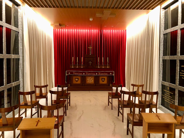
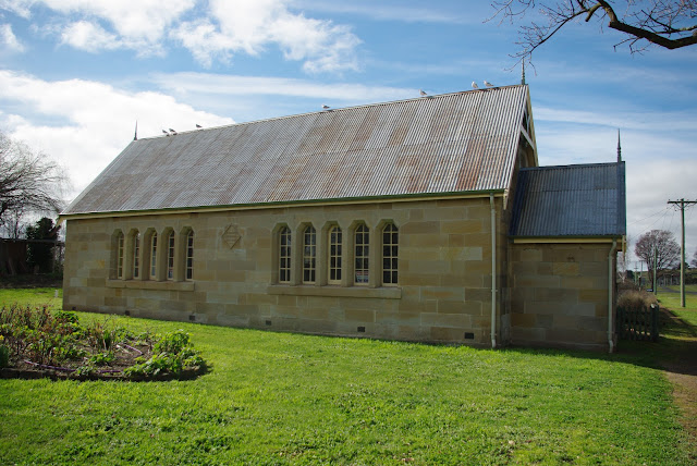
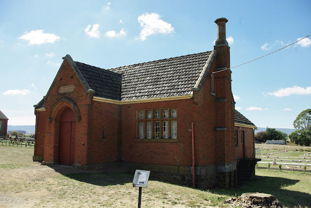
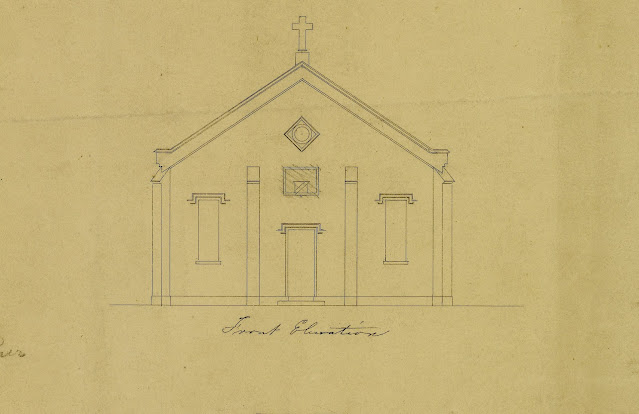
No. 1156 - York Plains - Anglican Church

Image
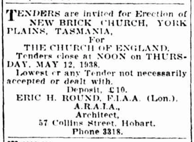
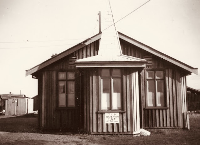
York Plains is a rural community approximately 10 kilometres northwest of Oatlands. It was named by Governor Lachlan Macquarie in 1811 in honour of the Duke of York. It had previously been known as Scantling’s Plains, after the bushranger Richard Scantling. By the close of the nineteenth century the population of the York Plains district had grown considerably. In 1898 a State school opened and a public hall was built in about 1914. Anglican services were held in the York Plains Hall for many years. Moves to build a church at York Plains began in 1935. ‘Church News’ reported that a church was to be built and that “people were donating three pence a brick”. In May 1938 an advertisement calling for tenders to build a new brick church at York Plains was placed in the Hobart Mercury. The proposed building was designed by architect Eric Round of Hobart. Round was the designer of several Tasmanian churches including All Saint’s at Margate and St Luke’s at Longley. Further progress was repo

No. 1155 - Pawtella (Mount Pleasant) - School and Church

Image
Pawtella is a small farming community approximately 20 kilometres northeast of Parattah. It is situated at the junction of the Pawtella and Nala Roads and is part of the former Mount Pleasant Estate. Pawtella is aboriginal word for "Ringtail opossum". In 1906 the Tasmanian Government enacted the Closer Settlement Act, which allowed government to purchase large tracts of land and subdivide these into smaller farming blocks which would enable settlers to become self-sufficient. The first property purchased by the Closer Settlement Board was Mount Pleasant, a property which had been owned by the O’Connor family since 1836. In 1908 the Closer Settlement Board began selling subdivided portions of the estate. In 1911 a State School was built and in 1914 the Mount Pleasant Hall opened. The State School building was also used to conduct church services with Presbyterian and Anglican worship taking place on alternative months. Along the school ground boundary a row of pine trees were

No. 1154 - Hobart - St Mary's Cathedral Crypt

Image
In 2021 I had an opportunity to view and photograph the crypt beneath St Mary’s Cathedral Centre, a 4 storey extension connected to the western side of the Cathedral, which was completed 2011. Beneath the ground floor lobby of the centre a crypt was built to receive and preserve the remains of all the Cathedral’s archbishops. In 2016 the first bishops to be interred in the crypt were Archbishops Tweedy, Guilford Young and D’Arcy. The remains of the first Bishop of Hobart, Robert William Willson, was interred in the crypt in 2017 after being repatriated from Nottingham in England. In September 2021 the remains of Archbishops Daniel Murphy, Patrick Delany, William Barry, William Hayden as well as the pioneer priest, Fr Philip Conolly, were exhumed from beneath the floor of the North Transept of the Cathedral. Their reinterment took place on 8 December 2021 following a Mass with the rite of interment. The remains of eight of the nine previous bishops of Hobart are now interred in the Cat

No. 1153 - Ross - St John's Sunday School

Image
This entry is another in a series of articles about buildings associated with some of Tasmania’s most significant churches. These buildings include Sunday schools, parish halls, convents, schools and residences of the clergy. Ancillary buildings are often overlooked and are rarely featured in published histories. My aim is to create a basic record of some of the most significant of these buildings, including those which no longer exist. Ross is a well known historical town off the Midlands Highway approximately 120 kilometres north of Hobart. It was named by Governor Lachlan Macquarie in 1821 after the Seat of his friend H.M. Buchanan of Loch Lomond in Scotland. The original St John’s Sunday school opened in 1847, ten years after the the town’s first Anglican church was completed on a hilltop site near the old cemetery. The school was rebuilt in 1902. Little information about the original building is available. It is not known if the design of the 1902 building is substantially diffe

No. 1152 - Saltwater River - Congregational Church (1905)

Image
Saltwater river is a small settlement on the Tasman Peninsula which is approximately 25 kilometres west of Eaglehawk Neck. It was once the site of two convict out-stations of Port Arthur Penal Settlement. Saltwater River was originally named Saltwater Creek. Little information is available about Saltwater River’s Congregational church. It was one of five Congregational churches established on the Tasman Peninsula. A fellowship was established at Saltwater River in 1900 with a meeting held in Ridler's cottage. The church was situated on land belonging to Mr. Ridler and was built by Mr Henry Wise at a cost of £ 40. The church was officially opened on Thursday 12 October 1905. A single short report published in the Hobart Mercury is the only reference to the opening of the church: “Next Thursday this new building is to be opened, and a picnic to the coal mines at Cascades is being given by the residents. The s.s. Ronnie is making a special trip from Hobart direct to Dunalley, thence

No. 1151 - Tea Tree - Independent Chapel (1840) and Old Cemetery

Image
Tea Tree is a partly rural settlement approximately 5 kilometres east of Brighton and about 20 kilometres north of Hobart. The name comes from a native bush which was gathered by the early settlers to make medicinal tea. In the early years of settlement the area was known as ‘Tea Tree Brush’ and ‘Tea Brush’. Theo Sharples [Congregationalism In Tasmanian 1830-1977] states that an independent chapel was built at Tea Tree in 1839: “Mr Beazley (Home Missionary) also visited the Tea Tree area where a chapel, opened in 1839, and a Sunday School flourished until, with regular services at Kempton, as Green Ponds township came to be known about 1838, the minister could no longer attend regularly at Tea Tree. The chapel had to be supplied by whomever available and, with the drift of population from the district, it fell eventually into disuse”. A search of newspaper records for 1839 reveals nothing about the chapel. However, the 1841 Annual Report of the Home Missionary and Christian Instruction

No. 1150 - Irishtown - St Joseph's Catholic Church (1904 - c.1989)

Image
Irishtown is a small rural town situated approximately 10 kilometres south of Smithton. The area was first settled in the late 1850s by Irish migrants when the area was known as Upper Duck River. The history of Irishtown’s Catholic church is unusual in as much as it is the story of unfulfilled and ambitious plans. The church was originally dedicated to St Patrick but this was changed to St Joseph in about 1910. The Irishtown Catholic community dates back to the 1870s and for many years Mass was occasionally held in local homes. In 1903 tenders were advertised for a wooden church with “dimensions of 52ft x 20ft” with a sanctuary and sacristy. The building was to be “of gothic design” and “shows some novelty in the construction of the open timber roof.” The foundation stone for the church was ceremonially laid on Sunday 20 September 1903: “Sunday last, September 20, was a red-letter day for the Catholics of Irishtown, when Monsignor Beechinor, parish priest of Launceston, laid the founda

No. 1149 - Ranelagh - St James' Sunday School (1886)

Image
Ranelagh is a township situated on the Huon River approximately 2 kilometres north of Huonville. Formerly known as Ranelagh Junction it had previously shared the name ‘Victoria’ with neighbouring Huonville. The Sunday school hall alongside St James’ Anglican church predates the the church by exactly 10 years. The present church replaced an earlier building that was destroyed in bushfires that swept through the district in January 1896. The fires came very close to destroying the Sunday school hall. A report in the Hobart Mercury records: “Fears were entertained for the safety of the Sunday-school, the roof of which was deluged with water, and thus a second catastrophe was avoided. Had the wind been blowing from the west nothing would have saved the Sunday-school…”. The hall was built in 1885 and opened in January 1886. No record can be found of the hall’s official opening. The original building was extended as can be seen from a turn of the 20th century photograph of the Sunday school

No. 1148 - Taranna - Evangelical Presbyterian Church (1972-2004)

Image
Taranna is a small settlement about 15 kilometres north east of the Town of Nubeena on the Tasman Peninsula. The settlement was the site of the Norfolk Bay Signal Station. The name Taranna, an Aboriginal name for wallaby, was adopted in the 1880s. The church at Taranna was originally St Matthew’s Presbyterian church at Tunbridge which was built in 1886. In 1972 it was transported to Taranna for use as an Evangelical Presbyterian Church. The church closed in 2004 due to poor attendances. It was purchased in 2009 for use as a Heritage Museum. The Evangelical Presbyterian Church was established in 1961. It is a small denomination with representation in Tasmania, Queensland and New South Wales. The church was founded in Tasmania and the ordination of its first ministers took place in Launceston. The Evangelical Presbyterian Church once had several congregations in Tasmania including Launceston, Hobart, Penguin and Winnaleah. Image: Google streetview  

No. 1147 - Flinders Bay - Probation Station Chapel (1841-1843)

Image
Flinders Bay is located on Forestier Peninsula and lies within Norfolk Bay. It is about 8 kilometres north west of Eaglehawk Neck. The ‘Probation System’ was an experiment in penal discipline unique to Van Diemen's Land. It was introduced in 1839 to replace the ‘assignment system’ which attracted criticism in Great Britain on the grounds that it neither reformed prisoners or provided a deterrent to potential offenders. Probation was similar to the penitentiary system which was built on the belief that both punishment and reform could be achieved by confinement and a regime of hard labour, religious instruction and education. More than eighty probation stations operated in various locations for varying periods. Many were hastily and poorly built. The Probation System was abandoned following the abolition of transportation to the colony in 1853. Religion was viewed as a critical tool in changing criminal behaviour. A 2008 UNESCO report on convict sites in Australia notes that this w

No. 1146 - New Town - Wesleyan Methodist Sunday School Hall (1892)

Image
This entry is another in a series of articles about buildings associated with some of Tasmania’s most significant churches. These buildings include Sunday schools, parish halls, convents, schools and residences of the clergy. Ancillary buildings are often overlooked and are rarely featured in published histories. My aim is to create a basic record of some of the most significant of these buildings, including those which no longer exist. New Town is a northern suburb of Hobart. It is also one of Hobart’s oldest suburbs and consequently the area contains many historic churches. New Town became a municipality in 1907 but was absorbed into Greater Hobart in the 1920s when its municipal status was relinquished. In the late 1850s, New Town’s first Wesleyan Methodist chapel was built at a site on Pirie Street. [ see No. 873] It was used for only seven years before it was replaced by the landmark church at the intersection of Cross Street and the Main Road. [ see No. 894 ] The church opened f

No. 1145 - Brighton Military Camp - Tasmanian Catholic Soldiers Hut (1940)

Image
Brighton Military Camp was located at the northern end of Brighton on the boundary with Pontville. The camp was established on the 13th August 1914 but lack of water impeded its development. After the first contingent left in October 1914 the main training camp moved to Claremont. During the Second World War a training camp was reestablished at Brighton, where huts housed up to 2400 trainees. As the need for training declined, Brighton Camp was used to detain Italian prisoners of war. After the war the camp was used to house migrants from Europe as well as national servicemen. In 1967 it housed victims of the bushfires and in 1999 it was temporarily used by 400 Kosovar refugees. The facility was closed in 2006 and sold to a developer in somewhat controversial circumstances. During World War Two, the religious and spiritual needs of servicemen at Brighton Camp were met by a number of denominations including Anglican, Methodist, Catholic and the Salvation Army. With support from the pub

No. 1144 - Campbell Town - St Luke's Sunday School (1845)

Image
This entry is another in a series of articles about buildings associated with some of Tasmania’s most significant churches. These buildings include Sunday schools, parish halls, convents, schools and residences of the clergy. Ancillary buildings are often overlooked and are rarely featured in published histories. My aim is to create a basic record of some of the most significant of these buildings, including those which no longer exist. Campbell Town is a sizeable rural centre on the Midland Highway approximately 70 kilometres south of Launceston. It was named by Governor Lachlan Macquarie when his party encamped here in 1821 on their way to Hobart. Macquarie chose the site as one of four garrison towns between Hobart and Launceston. In 1835 colonial architect John Lee Archer drew up plans for an Anglican church. In the same year Governor George Arthur laid the foundation stone for St Luke’s. However, serious defects in the structure meant that it had to be rebuilt from the windows up

No. 1143 - Port Arthur - Point Puer Chapel (1834-1849)

Image
Point Puer, situated on a narrow peninsula directly east of Port Arthur, was the site of Australia’s first purpose-built reforming institution for criminal boys. Operating from 1834 to 1849, it was initiated by Lt-Governor Arthur with the aim of making constructive colonial citizens out of transported boys through education, trade training and religious instruction. The degree to which this was achieved is a matter for debate. On 10 January 1834, 68 boys arrived at Point Puer along with supplies needed to establish the site. By the end of the decade 500 boys were living at Point Puer. Between 1842 and 1844 the numbers peaked at around 800. However, by the mid 1840s Point Puer was in rapid decline. The construction of the Parkhurst Reformatory on the Isle of Wight in 1838 resulted in fewer boys being transported to Australia. Point Puer closed in 1849 by which time about 3500 boys had passed through the institution. Most of the boys were aged between 15 and 17, a smaller number were und