Posts

Showing posts from 2021

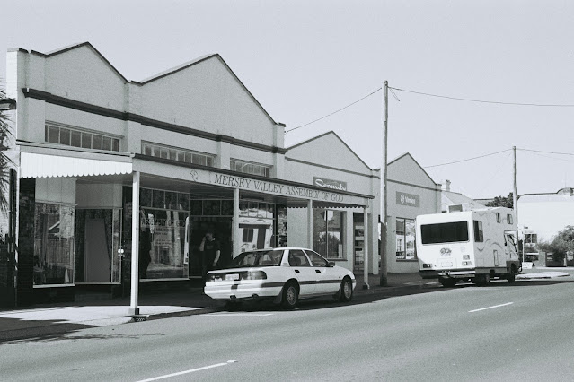
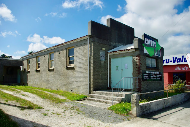
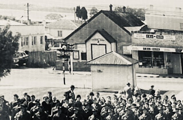
No. 1028 - Glenorchy - 'Edeline Gospel Hall'

Image
The city of Glenorchy is located approximately 7 kilometres north of Hobart's CBD. Glenorchy means ‘glen of tumbling waters’ and it is believed that Governor Lachlan Macquarie named the area after his wife’s birthplace; Glen Orchy, Argyllshire.The district was originally named 'King Georges Plains and the first centres of settlement were known as 'Kensington (village)' and ‘O'Briens Bridge’. Edeline Hall was built as public hall in late 1907 and was officially opened on Wednesday 1 January 1908. The hall was named in honour of Lady Edeline Strickland, wife of Governor Gerald Strickland. The hall still exists behind the facade of Bento Japanese take-away on Glenorchy Main Road, opposite the City Council offices. For many years Edeline Hall was a meeting place for social gatherings, political meetings, youth groups and occasionally for religious services and gatherings. By the 1950s the hall was in regular use by an evangelical Christian group; Worldwide Evangelizatio...

No. 1027 - Latrobe - Mersey Valley Assembly of God

Image
Latrobe is a large country town situated between the Bass Highway and the Mersey River. The first dwelling built on the town site was in 1836 and land sales took place some 20 years later. It was named after Administrator Charles LaTrobe, who was acting Lieutenant-Governor of Tasmania for a few months (1846-7). Latrobe was once an important port town with boats operating from Bells Parade until the Mersey River silted up. Little information is available about this former Assembly of God church which was located 129 Gilbert street. Up until the early 2000s the Assemblies of God was still a significant religious denomination in Tasmania. The Centre for Tasmanian Historical Studies provides the following review of the denomination: “Assemblies of God are made up of autonomous Pentecostal churches led by an elected state President. Pentecostals are distinguished by their belief in spiritual gifts, most notably 'tongues', prophecy and healing. They are generally characterised by con...

No. 1026 - Waverley - St Matthias' Anglican Church (1961-1966)

Image
Waverley is an eastern Launceston suburb made famous by the woollen mills, which carried its name. It was established as a housing subdivision in the 1950s. St. Mathias’ Anglican church was a short-lived church that was established in 1960. It opened in 1961 on a site on the Scottsdale Road (Tasman Highway) The building was gutted by a fire in 1966. As the church was not insured it was never rebuilt. To date I have yet to find a photograph of St Matthias’.  Additional information about this church is most welcome as all articles are updated. I can be contacted through this page or my Facebook page "Churches of Tasmania" which is linked here: < Churches of Tasmania >. Source: Henslowe, Dorothea I. and Hurburgh, Isa.  Our heritage of Anglican churches in Tasmania / by Dorothea I. Henslowe ; sketches by Isa Hurburgh, 1978.

No. 1025 - Gordon - Union Church (1933-1967)

Image
Gordon is a settlement on the Channel Highway about 25 kilometres southwest of Cygnet and which fronts onto the D’Entrecasteaux Channel. Gordon was once an orchard growing district. The area was previously known as 'Herne Bay' and 'Three Hut Point’. The Gordon Union Church, which opened in February 1933, replaced an early church also shared by the Methodist and Anglican communities. In 1932, when the construction of a new church began, the local correspondent for Hobart’s Mercury recalled : “Over 90 years ago a small dwelling was erected on the site where the new church is being built by two of Gordon’s earliest settlers, Messrs. John Behrens and Frederick Webber, for a Mr. John Abbott, an Englishman, who lived in a fine home with beautiful gardens and grounds, known as Rookwood, in the vicinity where Mr. Mason's general store now stands in Gordon. Many years later, after the disastrous bush fires of 1897 swept the State, the Gordon School, which for many years also ser...

No. 1024 - Cornelian Bay Mortuary Chapel (1873-1928)

Image
Cornelian Bay cemetery opened in 1872 after four of Hobart’s cemeteries were condemned as health hazards. Some, but not all bodies were exhumed and reinterred at Cornelian Bay. The cemetery was originally divided into sections for religious denominations: Church of England, Catholic; Presbyterian; Jewish; Quaker; Baptist and Independent. A War Grave and Pauper section were also established. It is estimated that there has been 100,000 burials and 60,000 cremations at Cornelian Bay. The layout of the cemetery was planned by Hobart architect, Henry Hunter, who was one of the original trustees of the Cemetery Board established in 1866. Hunter’s original plan proposed that each religious denomination would be allocated land for their own mortuary chapel. However, only a non-denominational mortuary chapel and a Jewish mortuary ‘Receiving Hose’ were built. In June 1872 Hunter submitted plans for a chapel which included a “temporary wooden edifice” until a permanent stone building could be...

No. 1023 - West Hobart - Christadelphian Ecclesia

Image
West Hobart is an inner-city suburb of Hobart immediately west of the city centre. The suburb occupies the high ground below Knocklofty Hill. The West Hobart Christadelphian ecclesia is located in Warwick Street in a building that was established as a Seventh-Day Adventist church. The church was built by the Adventists in 1896 and was vacated about 20 years ago when the Christadelphian’s acquired the building. The word ‘Christadelphian’ means ‘Brethren in Christ’. The denomination was founded in 1848 by Dr. John Thomas (1805-1871), who broke from the Disciples of Christ. Christadelphian’s hold several beliefs that differ from mainstream Christian denominations. They reject the doctrine of the Trinity and believe that Jesus Christ was a man. They do not mix with other Christian groups and have no interest in ecumenism. Members of this religion do not vote, do not run for political office, or engage in war. The word "ecclesia" is used by Christadelphians instead of church. Ecc...

No. 1022 - South Hobart - Davey Street Wesleyan Chapel (1838-1870)

Image
Davey Street Methodist Chapel was one of a number of Wesleyan-Methodist Sunday schools established in the greater Hobart area during the 1820s and 1830s. Sunday schools were sometimes also used as day schools and most served as places of worship. In fact a number of Hobart’s historic Methodist churches originated as humble Sunday schools. Hobart’s first Methodist Sunday school opened with 23 scholars on May 13, 1821. Robert Household and John Hiddlestone were the first superintendents. In 1824 a Methodist Sunday School Union was formed and schools were established at Liverpool Street; Sandy Bay; Kangaroo Point; O'Brien's Bridge and at the Penitentiary. A school was also established in a room near the corner of Liverpool and Harrington Streets. In 1832 a Sunday school and chapel was established in a house in Argyle Street. At a Sunday School Union meeting held on August 27, 1834, a motion was passed find suitable premises to rent for a Sunday school in either Davey or Macquarie ...

No. 1021 - Westbury - Wesleyan Methodist Chapel (1840-1866)

Image
Westbury is a historic town situated approximately 30 kilometres west of Launceston. It was surveyed in 1828 and was developed as an administrative centre for the district. For most of its history Westbury has been served by only three religious denominations. The town’s Catholic, Anglican and Uniting (Methodist) churches all date back to the first half of the 19th century. The Uniting Church located on William Street is the second Methodist church built in the town. It replaced the original Wesleyan chapel which was built and opened in 1840. The origins of Methodist activity in Westbury is outlined in Reverend Max Stansell’s book, Tasmanian Methodism: “On 11 July 1937 Rev. J.A. Manton of Launceston was requested to visit Westbury with the idea of establishing a preaching place. Within a few months of his visit a Methodist Class was formed. One acre of ground was granted by the Surveyor-General under a Location Order to Revs. J. Orton, J.A. Manton and W. Simpson at Westbury on 15 Nov...

No. 1020 - Smithton Gospel Hall (1941-2016)

Image
Smithton is the commercial and industrial centre of the Circular Head district in the far northwest of the island. The early settlement was known as Duck River but this was changed to Smithton in 1895. Smithton is named after an Irishman, Peter Smith, who had been a constable, and later the licensee of ‘The Plough Inn,’ at Stanley. Smith moved to Duck River after buying some 500 acres of land from the Poke and Ollington families. Smith’s successful enterprises enabled his return to Ireland. The Christian Brethren arrived at Circular Head in the late 1870s and the first regular services were held in a small hall at Scotchtown. In 1886 a Gospel Hall built on the King Street site. The focus of this blog entry is on the opening of a second hall on the same site in 1941. The history of the original hall will be the focus of a seperate article. In December 1941 the Circular Head Chronicle published a short report concerning the official opening of the hall as well as a description of the bui...

No. 1019 - Goodwood - Good News Centre (1962-2004)

Image
Goodwood is a small residential suburb starts just south-east of the Brooker Highway and Goodwood Road junction. Most houses in Goodwood were built in the 1950s as public housing. The Good News Centre is a former Assembles of God church located on Dodds Avenue. The building was constructed in 1962. After the church’s closure it was sold in 2004 and converted into a house. Little information about this former Assembly of God church is readily available. In the early 2000s the Assemblies of God was still a significant religious denomination in Tasmania. The Centre for Tasmanian Historical Studies provides the following review of the denomination: “Assemblies of God are made up of autonomous Pentecostal churches led by an elected state President. Pentecostals are distinguished by their belief in spiritual gifts, most notably 'tongues', prophecy and healing. They are generally characterised by contemporary worship. The Australian Assemblies of God commenced in 1937 when several fle...

No. 1018 - Hadspen - St Stephen's Anglican Church (1845-1961)

Image
Hadspen is a dormitory town on the South Esk River approximately 10 kilometres south west of Launceston. The early settlement was centred on a village near Reibey’s Ford. It is believed that George Frankland (Surveyor-General 1827 to 1838) named the settlement Hadspen after an estate in his native county, Somerset. Thomas Reibey’s iconic Church of the Good Shepherd, which remained uncompleted for almost a century, is the church most closely associated with Hadspen. Few will know that another Anglican church, St Stephen’s, served the community for almost 120 years before it was removed with the eventual completion of Reibey’s church in 1961. Little is known about this church and I have found only one photograph which captures a partial section of this building. I am hopeful that an image may exist. The church was moved after it was sold to the Methodists but I have yet to establish where it was moved or even if it still exists. The foundation stone for St Stephen’s was laid by Bishop N...

No. 1017 - Hobart - St Peter's Hall

Image
St Peter’s Hall is situated within St Mary’s Cathedral precinct at the corner of Harrington and Brisbane Street. The building originally stood on lower Collins Street before it was dismantled and reconstructed at its present site in 1904. St Peter’s Hall was built in 1855 as a temperance hall and school house as well as for occasional religious services. It is marked on Jarman’s 1858 map of Hobart where it is listed as a Catholic chapel. Two 19th century ‘birds-eye’ views of Hobart (see below) clearly show details of the building which was accessed by a footbridge across the Hobart rivulet. Lower Collins Street fell within a district known as Wapping, which was one of Hobart’s poorer quarters located close to the docks. This article draws from newspaper accounts from the 1850s which describe the halls construction and opening as well reports from 1904 concerning its removal and reconstruction near the cathedral. The Colonial Times records the laying of the foundation stone of St Peter’...

No. 1016 - Preolenna Gospel Hall (1924-1994)

Image
Preolenna is a small village at the junction of the Preolenna and Meunna Roads approximately 30 kilometres south of Wynyard. The first grants of land in the district were settled in 1910. In 1917 a tramway was constructed from Flowerdale to Preolenna to facilitate coal mining operations at the coal seams discovered in 1914. Preolenna is an Aboriginal word meaning 'to fetch or to bring’. Preolenna once had Baptist and Methodist communities which gathered for worship in the Preolenna Hall. The only church built at the settlement was a Gospel Hall which was constructed in 1924. In April 1924 the first working bee was held to clear land for the erection of a hall. A tender was for the construction of a building was awarded to Mr J. Sellers Jnr for an amount of £37. The official opening of the hall took place on Wednesday 12 November 1924 with the main speaker being Major Roberts-Thomson of Table Cape. Families associated with the establishment of the church include: Morse; Reeve; Hain...

No. 1015 - Blackmans Bay - St Peter's Anglican Church (1968-2016)

Image
Blackmans Bay is located adjacent to the town of Kingston and is approximately fourteen kilometres south of Hobart. It is named after James Blackman who made a claim for a grant of land in the area in about 1844. It was once a popular place for holiday shacks but is now a residential area. Plans to build a church at Blackmans Bay were developed in 1960. In 1968 the foundation stone for the building was laid and the church was constructed at a cost of $12 000. The church was dedicated to St Peter in October 1968. St Peter’s closed in 1916 and sold in the following year. The church and attached land has recently been developed for housing units. St Peter's Anglican Church (Google street view) St Peter's at Blackmans Bay (undated) photo supplied Source: Stephens, Geoffrey, The Anglican Church in Tasmania: a diocesan history to mark the sesquicentenary, 1992, Trustees of the Diocese, Hobart, 1991.

No. 1014 - Newnham - Newnham Fellowship

Image
Newnham is a northern suburb of the city of Launceston. Newnham was originally part of the municipality of Lilydale before it was proclaimed a town in 1946. There are several active Christian communities in Newnham including a Uniting Church, an Anglican church and a Church of Christ. The Newnham Fellowship is located in the premises of a former Catholic Church, Our Lady Help of Christians, which opened in 1968. Newnham Fellowship falls under the umbrella of the Association of Christian Community Churches in Victoria and Tasmania. The association describes itself as “a movement of like-minded local churches, predominantly of a Christian Brethren heritage, that have united under a common vision and mission, set of beliefs and core values”. The Christian Brethren, originated in Great Britain in the 1820s. By the mid 19th century the movement had spread to Australia, with the first revival meetings held in Tasmania from 1869. As a result, fellowships were formed in Hobart, Launceston, t...

No. 1013 - Glenorchy - St Andrew's Anglican Church (1958-1975)

Image
The city of Glenorchy is located approximately 7 kilometres north of Hobart's CBD. Glenorchy means ‘glen of tumbling waters’ and it is believed that Governor Lachlan Macquarie named the area after his wife’s birthplace; Glen Orchy, Argyllshire. St Andrew’s was built in 1958 and was opened and consecrated in the same year. The building was an old army hut from the Brighton Military Camp which was transported to Glenorchy and reassembled with some modification. As can be seen in the photograph, the church is constructed of rough hewn vertical board with a corrugated iron roof. The sanctuary and altar were built by Richard Lord. St Andrew’s was a short-lived church with religious services ceasing in the early 1970s. The site was sold and the building removed in 1975. St Andrew's at Glenorchy (1958) Source: Henslowe, Dorothea I. and Hurburgh, Isa.  Our heritage of Anglican churches in Tasmania / by Dorothea I. Henslowe ; sketches by Isa Hurburgh  [S.l  1978

No. 1012 - Hadspen - Grace Presbyterian Church

Image
Hadspen is a dormitory town on the South Esk River approximately 10 kilometres south west of Launceston. It dates back to a village near Reibey’s ford established in the 1830s. It is surmised that George Frankland (Surveyor-General 1827 to 1838) named the settlement after an Estate in his native county, Somerset. Hadspen’s Grace Presbyterian church is a recently established religious community. In 2019 a group of Presbyterian Churches in northern Tasmania began to work toward forming a new church to serve the south west corner of Launceston and the nearby towns in the Meander Valley and Northern Midlands. Initially worship was held in a private home but since 2021 the church has established itself at the Hadspen Memorial Centre. Grace Presbyterian Church is part of the Presbyterian Church of Tasmania and Australia, holding to the Westminster Confession of Faith. The community describes itself as catholic, evangelical and reformed. There are currently 14 active Presbyterian churches i...

No. 1011 - Smithton - The Salvation Army Hall (1930-1970)

Image
Smithton is the commercial and industrial centre of the Circular Head district in the far northwest of the island. The early settlement was known as Duck River but this was changed to Smithton in 1895. Smithton is named after an Irishman, Peter Smith, who had been a constable and later the licensee of ‘The Plough Inn,’ at Stanley. The Salvation Army first appeared at Smithton shortly after the turn of the 20th century. Over a period of about 70 years the Salvation Army built three halls at two different sites, both on Nelson Street. The first hall, which was built in 1908, was the subject of an earlier article. [ See No. 993 ] This article concerns the two later halls situated at 133 Nelson Street. After the closure and sale of the first hall in 1909, the Salvation Army withdrew from Smithton for a period of about seven years, returning in 1917. After this time worship was conducted in the Town Hall and other rented premises such as the Masonic Hall. In July 1930 it was announced that ...