Posts

No. 743 - Ellenton and Cuprona - The Anglican Church (1907-1921)
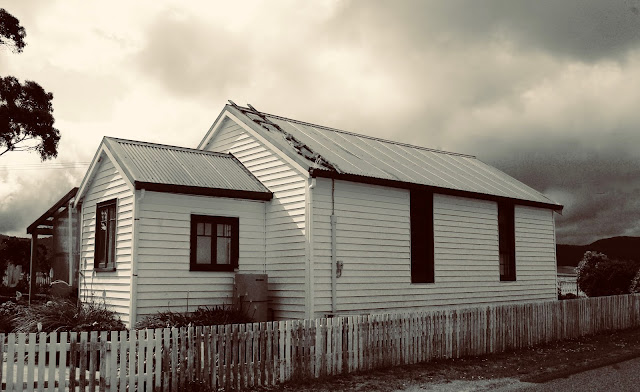
Image
The townships of Ellenton and Cuprona are situated about 15 kilometres south west of Penguin on the North West coast. The name Ellenton is no longer used and the area is now known as Cuprona. The two townships, which were a stone’s throw from each other were the product of a short-lived copper mining boom. An article published in the North Western Advocate and the Emu Bay Times explains the origins of the Copper King Mine and the two townships: “Three years ago there was a district boom in copper properties, and several local companies were formed to work ‘shows' on farm and Crown land in the Blythe— Stowport district. In those days the riches of the 'Copper King' made it the 'daddy' of the field, and it has since justified the confidence reposed in it. The property was then reached through Mr Charles Sice's farm, and the story goes that Mr Aubrey Sice discovered the hidden wealth quite by accident….Much money was sunk in it, and much time spent in negotiati...

No. 742 - Cambridge - The Uniting (Congregational) Church - (1843-2007)

Image
Cambridge is a suburb in the greater Hobart area and which in recent years has developed into an industrial estate and a commuter town. In the very early period the Cambridge area was known as Hollow Tree. The early history of the Congregational Chapel at Cambridge is poorly recorded. The chapel opened on Easter Monday, 17 April 1843. It is purportedly designed by the former convict architect James Blackburn. Although no description of the opening ceremony survives, an advertisement in the Colonial Times reveals that the service was conducted by Reverend Joseph Beazley, of Green Ponds (Kempton). One account of the chapel’s establishment states: “The church was formed as a result of the action of a former member of the Brisbane Street Chapel at Hobart, who, on taking up residence at Hollow Tree,….invited the Rev. Joseph Beazley, the founder of the Kempton Church, to conduct services in the district. Accordingly, until his departure from Tasmania in 1847, Mr Beazley held occasional se...

No. 741 - Seven Mile Beach - St Jude's Anglican Church

Image
Seven Mile Beach is a settlement immediately south of Hobart Airport. It is on the western end of the long beach that faces onto Fredrick Henry Bay. The only church established at Seven Mile Beach was St Jude’s of the Anglican Parish of Sandford. A timber building which cost $1100 was opened and dedicated as a church in December 1968. The church was a converted building purchased from the Lindisfarne Golf Club. In the 1960s the Club sold its land and buildings before moving to a new site at Barilla Bay. Before the acquisition of of this building, Anglican services were held at the Seven Mile Beach community hall. St Jude’s is no longer at Seven Mile Beach. In recent years the church was moved to Sandford to serve as hall for St Martin’s Anglican church. Both St Jude’s and St Martin’s were recently sold and the buildings are now the premises of Tasmania’s oldest karate club, International Karate-do. Additional information about St Jude’s is welcomed as all articles will be updated....

No. 740 - Ulverstone - Camp Clayton Chapel

Image
Camp Clayton is a youth church camp located on the north west coast and is situated approximately midway between Turners Beach and Ulverstone. Camp Clayton is owned by local Tasmanian Christian churches affiliated with the Christian Community Churches of Australia, previously known as the Christian Brethren. The Christian Brethren also developed youth camp sites at Blue Lagoon (Dodges Ferry) in 1961 and Riverbend near Smithton in the 1970s. Camp Clayton’s origins date back to January 1948, when the first Brethren youth camp was held at Wesley Dale near Mole Creek. In 1950 Wesley Dale’s facilities were turned into a hostel for Dutch migrants who worked on the estate thus a new camp site had to found. In 1950 a property on Clayton’s Rivulet near Ulverstone was purchased and an assembly hall, dining hall and dormitories were built by voluntary labour. The first Christian youth camp on the site was held in December 1950. In 1996 Camp Clayton purchased the former ‘All Saint’s Anglican ...

No. 739 - Ridgley Methodist Church - "A viler sight I have never seen"

Image
Ridgley is situated approximately 15 kilometres south of Burnie and in recent years has effectively become a commuter suburb of the city. It was once a small farming town established by the Van Diemen's Land Company. Ridgley also played an important part in the building of the Emu Bay Railway. The town has been well served by a number of religious denominations including Anglican, Catholic and Methodist. The Ridgley Methodist church was originally located at Stirling (also known as Nine Mile), the former name of a small settlement contiguous to the township of Ridgley. By the time of the Great War the name Stirling was dropped as the larger settlement at Ridgley overshadowed and absorbed its smaller neighbour. The first Methodist service at Sterling was held in May 1891 in the home of Mr and Mrs William Coventry. Between 1891 and 1897 regular services continued to be held in local homes until a paling hall with a shingle-roof was built on the property of Mr Cowling. The simple chur...

No. 738 - Hobart - The YMCA Chapel on Argyle Street (1953-1969)

Image
The ‘Young Men’s Christian Association’, an international movement for 'the spiritual, intellectual, social, and moral improvement of all within its reach', reached Tasmania in the late 19th century. The Association was formally established in Launceston in 1880 and Hobart in 1882. It was open to all boys and young men and promoted all-round development by providing activities such as social meetings, concerts, debates, lectures, reading and games. It encouraging sport, including boxing, soccer, gymnastics, swimming and walking. In earlier times most of its activities were grounded in prayer meetings, Bible classes and mission work. While the YMCA is no longer an exclusively male organisation, its mission is still founded on Christian values and to provide opportunities for the young to grow in body, mind and spirit. The association was introduced to Hobartians in June 1878 by the Reverend Dr. A. N. Somerville, who was then on a world tour. He delivered a lecture in the interes...

No. 737 - West Hobart - "St Michael and All Angel's"

Image
In 1918 the newly created parish of St Michael’s and All Angels was established in West Hobart, a developing and poorer part of the city. Services were initially held in local homes and also in the Kingsway Hall. In late 1918, Reverend Thomas Gibson, the rector of the new parish, acquired an old army hut from the Claremont Camp for use as a temporary church. However this was deemed an illegal structure by the council and never put into use. See [ No. 717 ] Despite this setback it was not long before a church was built. Given the economic austerity following the Great War it was decided to build a church hall and a church at a latter date. The foundation stone for St Michael’s was laid in February 1920: “Evidence of the interest which is being taken in the new St. Michael’s parish was manifested yesterday afternoon, when there was a large attendance at the ceremony of laying the foundation stone of St Michael’s Church-hall, which is to be erected near Franklin-street, to the rear o...

No. 736 - Wynyard - The United Free Methodist Church (1878-1922)

Image
Wynyard is a town on the northwest coast approximately 20 kilometres west of the city of Burnie. The area around Wynyard was originally named Table Cape by the explorers Bass and Flinders. The name was changed to Wynyard in the 1850s, in honour of Edward Buckley Wynyard, Lieutenant-General of the New South Wales Corps. In his capacity as commander of troops in New South Wales, Van Diemen’s Land and New Zealand, Wynyard visited Table Cape in 1850-1. Until the 20th century Wynyard remained a small town with a population of less than 500. The United Free Methodist Church was the fourth church to be established at Wynyard. It was originally located near Wynyard’s railway station at the western end of Dodgin Street before being moved twice and it is now situated alongside the Uniting Church on the eastern end of Dodgin Street. It should not be confused with Wynyard’s Wesleyan Methodist Church which held services in the Town Hall before the Methodist Union of 1902. The Free or Independent Me...

No. 735 - Wivenhoe - Salvation Army Hall

Image
Wivenhoe is a suburb of Burnie situated on the east bank of the Emu River. It has developed into an industrialised area which is located about 3 kilometres south-east of the city centre. It is named after the town (and parish) of Wivenhoe in Essex County, by Captain Henry Butler Stoney in the 1850's. The Salvation Army was formed at Burnie in the 1890’s and further ‘outposts’ were established in neighbouring Wivenhoe in the 1940s and at Montello, Upper Burnie, in the 1950s. There are few available records about the Wivenhoe Salvation Army Hall and I have found only a single photography of the building which can be seen in a general view of the suburb. The first public service at the hall was held on Sunday 17 December 1944. This was reported in the Burnie Advocate: “The first public service held in the new Salvation Army Hall at Wivenhoe was conducted last evening by Major R. Sutton. There was a large gathering. The hall, situated in Smith street, was erected on a block of land don...